
A frosty sunrise, the details highlighted by the smog of household fires from the night before. 28th July 2007
Taken April 2009, this is the eastern side of a large panorama showing storm squalls moving across Christchurch into the sea with beautiful clouds forming above Pegasus Bay. Be sure to check out the western side of this panorama.
Taken April 2009, this is the western side of a large panorama showing storm squalls moving across Christchurch into the sea. Be sure to check out the eastern side of this panorama with beautiful clouds forming above Pegasus Bay.

Before the storm the boats lay still in Oamaru Harbour.
A digitally painted piece showing the dramatic clouds minutes before sunset in this beautiful location.
European settlement at Oamaru began in 1853 when Hugh Robison built a musterer’s hut on the foreshore. North Otago was good for sheep-runs, and in the 1860s the town grew rich servicing pastoralists and gold miners.
Oamaru, though, was no port. Cape Wanbrow, a stubby little headland, gave some shelter from southerly winds but none from easterlies. In the absence of breakwaters and wharves, ships anchored in the open sea, loading and discharging cargo into surf boats. It was slow, sweaty work.
It was also dangerous. Cables guided the surf boats through the breakers in a hair-raising surge of foam. Once on the beach, the boat crews sledged them up to a cargo shed. Passengers received similar treatment. As the boats approached the beach, boatmen waded out, took the passengers on their backs and carried them ashore.
This was possible only in fine, calm weather. Ships’ captains kept a weather eye on the horizon. At the first sign of danger or a shift in the wind, work stopped and they fled out to sea.
Oamaru’s exposed beach made it one of New Zealand’s most dangerous anchorages. More than 20 ships were wrecked there between 1860 and 1875, and many more were damaged and recovered. In the worst example, on the night of 3–4 February 1868, a huge storm wrecked a new jetty foolishly built out into the bay from an unprotected site, as well as the ships Star of Tasmania, Water Nymph and Otago. Four people drowned.
'Oamaru Harbour', URL: https://nzhistory.govt.nz/culture/oamaru-harbour, (Ministry for Culture and Heritage), updated 20-Dec-2012
Behind the hustle and bustle of Harbour street lies a quieter place, sometimes dark.

Below Benmore Dam, Waitaki, willow trees grow. A digital painting by Derek Golding.
Benmore Dam is the largest dam within the Waitaki power scheme, located in the New Zealand's South Island. There are eight other power stations in the Waitaki Power Scheme.
The dam is the largest earth-filled water-retaining structure in New Zealand. Its core is low permeability clay material, supported by two massive shoulders of river gravel. Lake Benmore has a volume of 1.25 billion cubic metres, about 1.5 times as much water as Wellington Harbour. The dam's spillway can cope with 3,400 cubic metres of water per second, about 10 times the mean river flow.
Canterbury Fire I, a stunning sunset taken from close to the car park at the base of Mount Vernon, Banks Peninsula.
From memory these were taken Late August 2010, 1 week before the first earthquake hit the district.

Canterbury Fire II, a stunning sunset taken from close to the car park at the base of Mount Vernon, Banks Peninsula.
From memory these were taken Late August 2010, 1 week before the first earthquake hit the district.
The panoramic "Night" was taken after the this sunset, the lights of the city starting to awaken.

Christchurch City East, one of Derek's earlier panoramic photos of Christchurch City, as seen from the Port Hills.
Created on the 6th of October 2007 using a powerful telephoto lens, hundreds of images were taken of the city then stitched together using Autopano software by Alexandre Jenny, of Kolor fame.
This image is the East side of a larger panoramic, the West side is also available to purchase, or you can contact us for a special edition full sized print.
This image is also a zoomable interactive tour in our Gigapixel section.
Sit back and take time to explore.
Christchurch City West, one of Derek's earlier panoramic photos of Christchurch City, as seen from the Port Hills.
Created on the 6th of October 2007 using a powerful telephoto lens, hundreds of images were taken of the city then stitched together using Autopano software by Alexandre Jenny, of Kolor fame.
This image is the West side of a larger panoramic, the East side is also available to purchase, or you can contact us for a special edition full sized print.
This image is also a zoomable interactive tour in our Gigapixel section.
Sit back and take time to explore.
Gibraltar Rock, nestled in the Port Hills near Christchurch, at sunset. Atop the rock a lone figure stands with arms outstretched, warmed by the last rays.
This shot was planned well in advance, hoping for a clear day during a narrow window of opportunity, we managed to capture the sunset at just the right moment.
The end of Holmes Wharf at night is an eerie place. Crashing waves, birds calling coming home to roost, penguins and the occasional rabbit about your feet.
A slow exposure stitched panoramic image, beautiful colours that will give warmth and depth to any room.
Oamaru Breakwater and Holmes Wharf, slow exposure, 25th May 2009.
A curious place to be at night with all the penguins, rabbits and seabirds hustling around you, getting ready to settle down.

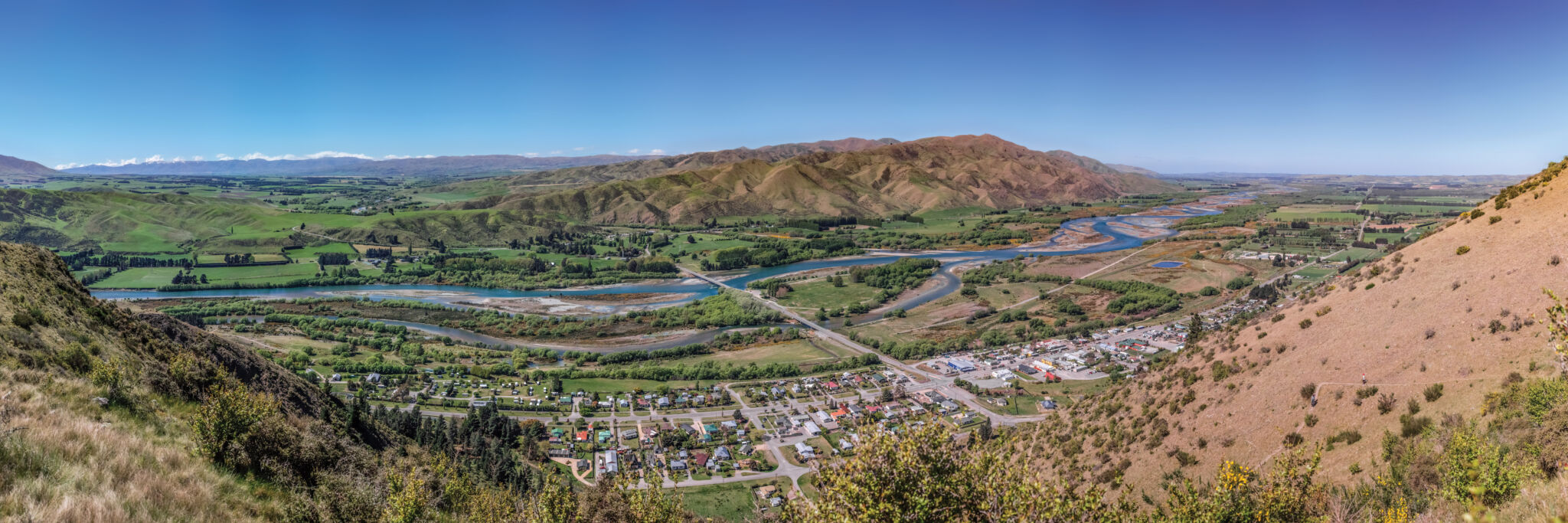
This panoramic shows the Waitaki Valley from above Kurow township. A path leads to this point from the road below. At the top you will see this image on a sign that shows all the mountain names in the distance.
Below we can see the A2O bike trail, used by over 60,000 visitors a year.
Check out a tour at Virtual Waitaki, showing this location and many others along the valley, or click on the box below to explore.
The Lindis Pass is a stunning route to take on a trip around the South Island of New Zealand. A true spot for "4 Seasons in One Day", even in summer touches of snow can appear when a cold front moves through.
The Lindis Pass is a stunning route to take on a trip around the South Island of New Zealand. A true spot for "4 Seasons in One Day", even in summer touches of snow can appear when a cold front moves through.
Panoramic image with red filter applied to darken the skies.
Behind the hustle and bustle of Harbour Street, storm clouds gather above the railway yard.

A Digital artwork showing the beautiful Oamaru Harbour at sunset, the boats still lit by the setting sun.
Shortly before sunset, the sun dips below the nor-wester arch to light up the motionless boats in Oamaru Harbour.
The little town of Oamaru, the town that could! A digital painting by Derek Golding
Oamaru a beautiful little town on the east coast of the South Island of New Zealand. Home to GoldingArts and the location of many of Derek's phtotographs and artworks.
Oamaru is well worth a visit by any photographer or artist for the stunning views.


GoldingArts
Be sure to follow our social pages for offers and updates.
Popular products
Featured products
-
 Holmes Wharf at night
Price range: $132.30 through $456.30
Holmes Wharf at night
Price range: $132.30 through $456.30 -
The Lair
Price range: $132.30 through $456.30
-
The Luminous Wave III
Price range: $132.30 through $456.30


© 2007 - 2026 • GoldingArts • All Rights Reserved • Privacy Policy • Terms and Conditions